 |
|||||||
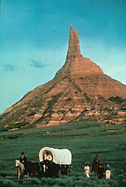
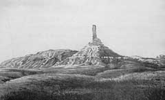
Located some twelve miles west of Courthouse and Jailhouse Rock, Chimney Rock was one of the most picturesque landmarks along the Oregon Trail. It signaled the end of the prairies as the trail became more steep and rugged heading west towards the Rocky Mountains. Many drawings of it were made by surveyors and artists, and most pioneers mentioned it in their diaries. Travelers reported that it was visible forty miles away. General Joel Palmer, leading a surveying party in 1845, said it had the "appearance of a haystack with a pole running far above its top." Many 19th century accounts stated that Chimney Rock was losing its height due to erosion. But some measurements recorded back then are very close to the modern measurement of 325 feet from tip to base and 120 feet for the spire.
|
|||||||
|
|
Independence | Courthouse
Rock | Chimney Rock | Fort
Laramie | Independence Rock | Fort
Bridger | |
|||||||
 |
|||||||